The Measure of This Life

We’re here at Newport Beach, California, on a mooring ball among the multimillion dollar houses with million dollar boats out front. It’s a little surreal, but lovely. We are still coming down from our high of being in the Channel Islands since October 14 (minus 3 days in Channel Islands Harbor). The time really flies when you spend that long somewhere. Even though we changed anchorages and islands, they are all a part of a larger unit of ‘the islands’ and so it was easy enough to get accustomed to being there; to even feel a bit like we could belong there in some way.   When that happens we have a saying: “We live here now.”. It’s amazing how fast I can begin to put down feeler roots in a place; not deep tap roots, but just those shallow little surface roots that pull in moisture and nutrients from the soil of a new land. After months of travel, it’s restful to look at a landscape and know the larger context of what you will see. It allows one to have the time to notice how the light changes from one day to the next; to allow a place to become ‘familiar’ in its way. It doesn’t take long for familiarity to begin to take root.

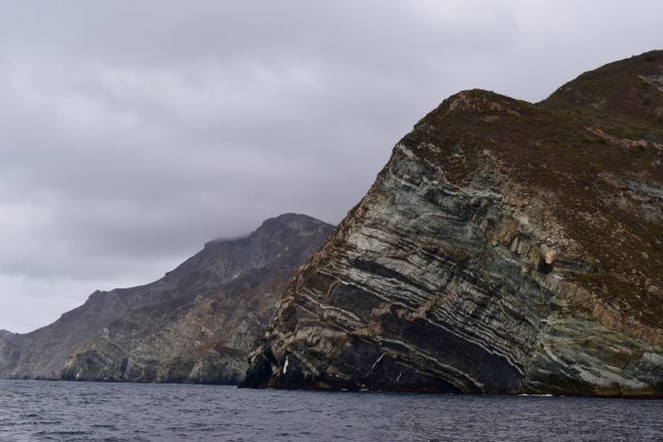
Scorpion Anchorage. A favorite when the weather is good. With S/V Blue from Gig Harbor in the foreground.

As we left Catalina Island I felt like it was time to take stock of how far we’ve come as cruising sailors. It feels like the leaving of Catalina Island marks a turning point in our travels as now we prepare in earnest to make a big leap across the international border into another country: Mexico. While that border is not very far away in terms of miles, it feels like another world in terms of our lives. We’ve been casually hopping down the coast of California with no real feeling of a destination, no feeling of hurry. Suddenly, we feel a little pressure. We need to get somewhere now because we have other things we will be doing over the holidays. There are decisions and reservations to make; airline tickets to buy. We also need to do the final push of buying insurance, and purchasing anything we feel we may need on the boat that would be hard to come by in Mexico.  I feel barely ready, so it must be time to go. That’s how it goes out here; that’s the name of the game. We’re just barely ready: let’s go.

This ‘crusing’ thing is filled with leaps of all sizes into the void of uncertainty. You leap away from a job and a home, then away from your home waters and into the big ocean. You jump right into landing in new places and dealing with unfamiliar weather patterns and seas and people. You do this because there is no choice. It’s either jump or stay home. No amount of reading of cruising guides or sitting through seminars can prepare you for sudden 35 knot winds in a crowded anchorage, or even an uncrowded one for that matter. No amount of perseverating or talking to more experienced cruisers can prepare you for landing your dinghy on a beach in surf.

Those dolphins!

You can read about high winds and higher swells and how to handle them all day long, but until you are trusting your life to your boat in these conditions, it’s all just academic. These are times when you have thrown caution to the four winds and hoped they would not hand your ass back to you on a platter. To live the life of a cruiser by sailboat is to live the life of a gambler; some days more than others. You have to be there to understand these things that by their nature are organic and multi-dimensional and not easily put into words.

After three months of easy cruising and protected waters in Washington State, we made the big Left Turn Leap at Neah Bay on Sept 3 and made landfall in the San Fransisco area on Sept 8. We’ve been exploring the coast of California now for 2 months. In those two months we’ve been to 26 different places and have spent a total of 6 nights at a dock – 3 in Pittsburgh and 3 in Channel Islands Harbor. At both places we were getting out of weather, seeking more shelter. At those places we took on fuel (103 gallons, and 75 gallons respectively) and water (167 gallons and 150 gallons). Those are the only quantifiable things about the last 2 months.

Other things are not so easily measured: how we’re more tolerant of higher winds than we were, how we can sleep through a surprising amount of boat motion, how used to being wet with salt water we’ve become, how 68 degrees can begin to feel chilly. How I finally do not want to throw up every time we approach a dock. How long ago our previous life aleady seems. How very much we trust our Mantus anchor. How our stress levels have gone down exponentially. How we can get accustomed to linens that never quite feel dry. How long we can go without washing our clothes. All the many ways one can cook eggs.

Nice to see you Mr. Coast Guard Cutter. Please keep pace with us a little longer in these nasty seas. Why yes, perhaps we are a little crazy being here.

Cruisers say that this life is filled with highs and lows, even more so than land life. I guess that’s true to some extent. We’ve been lucky so far. The low points have been few and they’ve primarily been due to running from weather and, a bit, from missing our kids and family. In the San Fransisco area I hit a low spot because the wind just never stopped and I was overwhelmed by it. We went up river to Pittsburgh to get out of the wind for a few days. When we left San Fransisco, I never looked back. I know people love it there, and it certainly is beautiful, but it was too much for me. Possibly part of that is because we had just spent 5 days at sea where there is peace and quiet and the possibility of seeing another sailboat is a treat. Coming into San Fransisco Bay after that is a bit of a shock.

In the Channel Islands we had some significant low spirits; again wind and sea state related. It seemed like we would get 1.5 good days before we’d have to run from high winds and swell again. We had 35 knot winds at one point, and of course, the seas to match. One night on Santa Cruz Island we found ourselves on a lee shore with huge swells left over from high winds earlier in the day.  We had zero protection from the high swells.  We pulled anchor at night and moved a short distance to what we hoped would be a more protected area, where we had anchored before. It was not a good experience and it didn’t help our position that much in the end. We rode it out but that was a very low place for me and I was extremely angry about it.

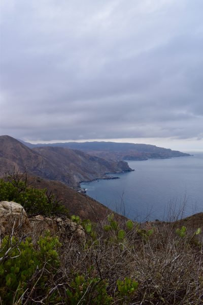
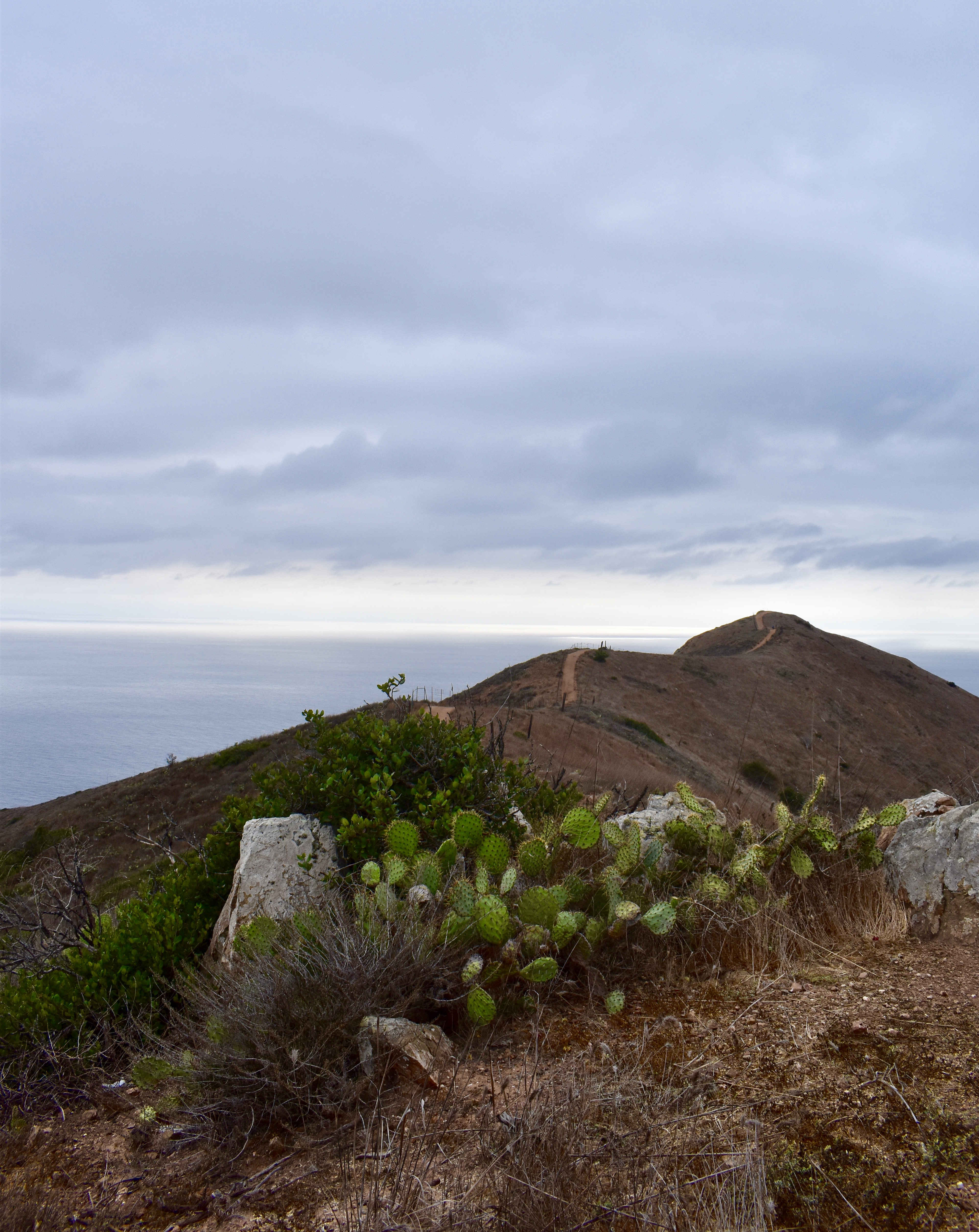
Yes, there were a few times when I felt like I was just done in by those most northern Channel Islands. But they are so beautiful, the hiking is so excellent,  and we really wanted badly to see them. Just when we both thought we’d give up, we’d find a safe anchorage, and then we’d sleep, and well, the next day somehow we always chose to stay. It’s either a form of denial or a kind of craziness, but for some reason those lows points just didn’t make us want to give up all that beauty. Maybe we just didn’t want to be beaten like that.  In my log book I wrote, “These islands are beautiful, but they take their toll in exchange.”.

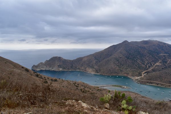
Yes, the Channel Islands are more than challenging this time of year. But then there’s this.

So far, the highs have far outweighed the few lows we’ve had on this trip. These are the unforgettable moments that have marked my human soul forever: hearing a sea lion hunting through the hull, those huge phosporescent animals in the deep ocean, that time when the setting sun and a rising full moon perfectly opposed one another off the coast, spotting a sea turtle underwater, and an octopus, and a pipefish, and a bat ray. All of the sea otters. That time the hundreds of dolphins swam with the boat, and that other time we saw a long line of dolphins and sea lions in formation together, driving prey.

The precious grunting of elephant seals. The clan of curious sea lions that rushed toward us from the shore, surrounding our dinghy with their leaping and playing and spying.  The baby sea lion snuggling up to our hull. The sweet relief of a safe anchorage. All the millions of stars in the sky at San Miguel Island. The thousands of white fish swimming toward our spotlight, as far as the eye can see. The complete surprise of pelagic crabs. Swimming in a school of fish, as though they’ve accepted you as one of their own. These things cannot be counted. They cannot be put in a box. They spill out in giddiness that it’s all turning out as well as we imagined so far, that all our hard work has not been for naught.

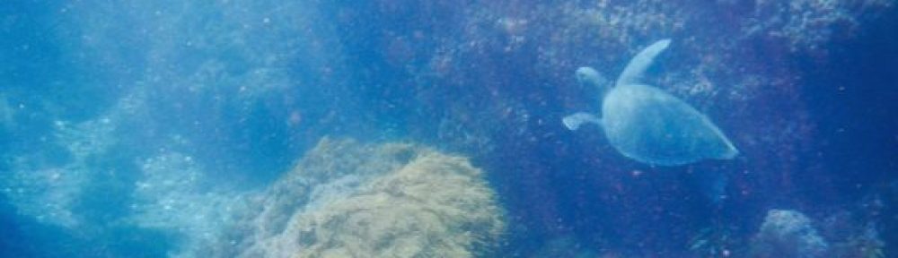
One of the two sea turtles I saw off Catalina Island.

And after two months of this kind of exploration, we cannot go back willingly into the box from which we leaped. Our old lives are far behind us now. Some days we miss our home, but mostly we don’t. Living this way has opened up a wide range of possibilities for the future in terms of where we live, and how we do it. We are only just beginning to understand this and play in our minds with the many ideas that come forth.  I don’t know how long we’ll be traveling by boat,  or how far we’ll go. I don’t know. And for now, that’s just fine. Next stop San Diego, then Mexico.

We plan to put Galapagos in a marina for a nice rest for 1-2 months once we reach Mexico. She will be in one of the marinas in Ensenada while we travel to Ecuador to visit Claire and Dan, then go back home for a visit with Andrew and Jill (who are now engaged to be married next fall!) and our family and friends. When we return, we plan a slow trip with many stops down the Pacific side of the Baja. We’re almost ready. Let’s go!

S/V Galapagos, Out.

As the sun went down…

The moon came up.


Catalina Island Time

We’re reading all these posts from cruising boats that are checking into Ensenada at this point. The Baja HaHa took off from San Diego on October 28, so they are all gone. But we are still here anchored off Catalina Island because, well, why not? We’re having fun and what’s the hurry? Compared to where we come from, this weather is downright balmy. Today the clouds have lifted and we’ve got sunny skies with puffy clouds and 68 degrees Fahrenheit. So we’re happy to hang out here for awhile in what feels like endless summer.

Yes! It’s a Bald Eagle! Eagle-eye Mike spotted this guy from the deck of the boat in Catalina Harbor. Bald Eagles were re-introduced to the Channel Islands. Due to human interference, they had been eliminated by the 1950’s. This is eagle number 82, as noted by the tag on its wing. We miss all the big eagles up in the Pacific Northwest so we were thrilled to see this guy.

The first time I visited Catalina Island was about 15 years ago when our son, Andrew, was about 10 or so years old. It’s too long ago to actually remember the year. Mike was in Newport Beach on business and we had come along with him to see the area. We took the foot ferry over from Newport and visited Avalon. The highlight of that trip was renting snorkeling gear on the side of the road and jumping in the water to see the fish and take photos with our cheap little disposable underwater cameras. It was great fun and I hope Andrew remembers it as fondly as I do. If you’d told me then that in the future I would visit on my own boat, I would have scoffed at you and thought you insane. But here we are.

I thought ‘Mourning Dove’ at first. But looking at the photo I think maybe ‘Eurasian Collared Dove’? Pretty anyhow.

We started our island tour at Catalina Harbor, on the ‘outside’ of the island. This place turned out to be just terrific. (But it was a seriously good call to enter this harbor during the light of day.)  It’s really well protected and we were able to anchor close to the hill just inside in about 20 feet of water with plenty of swing room. We could see the bottom in the clear, green water. But best of all is that this cove sports a real dinghy dock, the kind you can actually pull up to and tie off your dinghy. From there it’s a short walk across the isthmus to the little ‘village’ of Two Harbors, which is  more like a resort, really, than a town. The whole area has a ‘company store’ kind of feel since every building has to do with the tourist industry. There’s a laundromat and a general store with a few fresh items of food, as well as a restaurant/bar that has Happy Hour specials, even when there are hardly any tourists around like now.  We highly recommend their Chicken Taquitos with your beer.

The place is practically deserted. In fact, we had the use of these lovely Palapas which generally rent for 150$/day. Our price: 0$. After a challenging hike up to the peak of the mountain (the word ‘grueling’ actually comes to mind as you gain 1400 feet in altitude in 1.8 miles), we had our picnic lunch in one of these little units and then Mike stretched out for an afternoon nap on the divan while I hunted for rocks on the beach. It was lovely.

Just making ourselves right at home here.

All of these are empty. So fun!

I’m sure things will pick up a bit over the weekend, but during the week we really have been almost the only boat here.  We like that just fine. It means we don’t have trouble finding an anchorage, when there is almost no area for anchoring that is free of mooring balls. Seriously, can they fit any more mooring balls in this place? Is there any single area that is not fraught with these moorings but is still a desirable place to be? Of course, precious few of them have any boats on them right now. After a couple of days exploring the hiking trails at Two Harbors we are at Emerald Cove with its hundreds of moorings, all empty. If we wanted to tie up to one it would be about 50$ a night.  I’m not quite at the point in my life yet where it’s worth it to pay that amount for a mooring ball. Luckily, we have good anchoring gear on board so here we are.

A nice rewarding view after a tough climb. Can you find Galapagos down there in Catalina Harbor? This harbor has a number of boats on moorings but they look like they are permanently attached.

And the view in the other direction. The Trans-Catalina Trail goes along the topmost ridges of the mountains.

We’ve had two great days of snorkeling the rocky reefs here and we look forward to more snorkeling and hiking as we move along the coast of this beautiful island. We do want to visit Avalon, especially to snorkel there where Andrew and I had so much fun years ago. Sure hope we can find an anchoring spot close by. And I have to go to Moonstone Beach to find some moonstones. I found what I believe to be moonstone on the beach at Twin Harbors and it’s whet my appetite to go rock hunting again. I’ve been very good about not bringing rocks on board so far on this trip. But those days may be numbered.

Pretty Garibaldi, the California state fish.

It’s great to not have a schedule. I highly recommend it. Some day we’ll make it to Newport Beach and San Diego, then another day we’ll make it to Mexico. Meanwhile here are a few more photos. To get up-to-the-day photos, follow our Little Cunning Plan page on Facebook.

Our trail continues on. But we don’t.

The isthmus connects the two harbors: Catalina Harbor on the left, Isthmus Cove on the right. Note the trail up the ridge.

The magnificent Ribbon Rock, on the outside of the island close to Catalina Harbor. Incredible.


You Can’t Get There From Here

I’m so glad we’ve had the opportunity to dawdle down the California coast. This experience has allowed us to realize just how much we don’t know. And when I use the word ‘realize’ what I mean here is ‘experience in real time’. We learned to cruise in the Pacific Northwest’s protected waters. We are now beginning to ‘realize’ how easy that is compared to other places. There are more protected anchorages; places to get out of the weather, and it’s way easier to get to shore.

Typical Pacific Northwest beach. Take note.

For the non-boaters, when living and traveling on a boat, you have two choices about how to get to shore. Three if you count swimming. You can dock your boat or your dinghy at a dock or you can land your dinghy on a beach.  We learned to be good anchor-outers in the Pacific Northwest. Even in the wild and wooly west coast of Vancouver Island, we prefer to anchor out and take our dinghy to shore. Where we come from, here’s the simple routine for dinghying ashore when there is no dock: get in the dinghy. Go to shore. Gently land on the pebble, rock, or sandy beach. Maybe step into ankle deep water to pull the boat up the slope. Find tree or big piece of driftwood. (See photo above.) Tie dinghy off and have a great hike. That is all.

In addition, there are an amazing number of places that have a dinghy dock of some kind, even when there is no town. Those docks are low enough to tie the boat to a cleat and climb up onto the dock. Most towns have public dinghy docks if there is water access. In all the years we boated in Puget Sound and the Salish Sea, finding a place to land a dinghy was never a problem. After visiting the Channel Islands in southern California for the last 2 weeks, we now have a new appreciation for the dinghy privilege with which we have become accustomed. The wilds of these California islands have schooled us about  all we took for granted in our home waters. The dinghy-landing rules here are very, very different. Here’s how they go:

1.)  Approach shoreline. Determine that the surf is going to kill you. Go back to  the boat.  Look at land longingly from cockpit. Imagine walking for for than two steps in a row.

OR
2) Assess the shoreline. Notice dock. Notice dock is 20 feet high with steel ladder leading from water. Measure surge and realize it’s kind of big. Too big. Decide you’d rather not die that day. Stay on boat. Look at land longingly from cockpit. Make up stories in your mind about that time you took a long walk. Consider a long swim.

OR
3). Assess shoreline. Notice that the surf is manageable. You might get hurt, but you probably will not die. Approach shore in the correct perpendicular-to-waves manner.  Jump into thigh deep water as the boat begins to turn sideways as steering is lost in the approach to shore. To let it go is to risk it flipping over or being pooped by a wave. Walk boat to shore, grateful to have kept all 11 pair of water sandals that some people said you would never need.

I am not making this up. These are pretty much your choices.

Beautiful San Miguel Island. Worth it. The surf only looks small from far away.

Up close, it looks more like this:

This is actually more like the waves at Smuggler’s Cove. But in actuality it’s a wave a Santa Barbara Island.

Let’s take the landing we did on San Miguel Island. There was surf, but the beach was sandy and the water was warm. The waves were not too bad and we surfed our dinghy onto the beach. I only got two bruises on my legs from that landing after scrambling into the surf to keep the boat going in the right direction. We pull the boat up onto the beach and there is literally nothing to secure it to. Not knowing how far the tide might come up, because the tides are different here, we end up pulling the 135 pound boat as far up on the beach as possible to the one log that was way above the tide line. I just cannot relax knowing the boat isn’t tied to something. I better get over that because, get this: these beaches have no driftwood and no trees! Who knew??

Here’s the other thing: if you come back to your dinghy and the surf’s down, you better thank the sea gods of your choice and get that boat in the water immediately because if you wait even 10 minutes, the gods will consider you ungrateful, wave their mystical arms and surf will be up again and you’ll have to wait that out or risk certain death. Yeah, we learned that as well. When we got back to the dinghy on San Miguel, surf was down. But we started talking to two other sailors, ignoring the gift that had been given us. Pretty soon the surf was back up. Our new friends offered to help us get the dinghy launched.

That was a mistake. If it takes more than two of us to launch the boat, we need to wait. The boat got turned sideways, Mike turned his back on the sea (A BIG mistake) and before you could say ‘poopedy doop’ a big wave had risen up, grabbed the dinghy, and dumped many gallons of water into it. Mike got a nasty surprise and a thorough soaking but very fortunately did not get hurt.  Good thing I 100% of the time put my stuff in dry bags that are securely clipped into the boat. Otherwise my new camera would have been toast.

That surf doesn’t look too bad, does it? Waves only a little over a foot high coming in. Of course, this photo is take from above the waves. But even with surf this tame, you don’t want the boat getting sideways on you.

At that point we DID need those other two sailor lads because with a dinghy 1/4 filled with water, there was no way we could have dragged it out of the surf by ourselves. It was already digging itself down into the sand in a nice wallow. It took all four of us to pull it out, get it turned over and the water drained. Then we tried again. This time Mike and I walked it out past the waves, he got in and started the engine as I gave the dinghy a final shove and flopped in.  Oh, and did I mention there were lots of little Leopard Sharks in the water. I tell you this, I was glad I knew they didn’t have big teeth so they aren’t dangerous (and in fact they are kind of cute). But where there’s one kind of shark…. Damn. I think the total number of bruises for that day was 4.  Even so, San Miguel was fantastic and I would launch that dinghy in surf 100 times to go there.

Next was Smuggler’s Cove on Santa Cruz Island. We went to Smuggler’s Cove on the recommendation of our cruising guide, “Exploring the Pacific Coast” by Douglass and Hemingway-Douglass. Here’s what it says about the cove:

“There is a nice beach here, an old ranch adobe and olive tree and eucalyptus groves on the otherwise dry grassy hills.”  That is all.

This surf at Smuggler’s Bay doesn’t look bad, until you realize you can’t really see where it hits the beach, because the water drops out of sight. Because the surf is that big. Those little splashes are only the very top of the surf. That’s how high the swell is.

And that is an accurate statement, except for the part about the beach, which we cannot confirm. We cannot confirm it because my life is worth so much more than trying to land our dinghy anyplace with a rock beach and waves that are literally thundering, they crash so hard. The swells were so huge that Galapagos disappeared behind them as we motored our dinghy in front of her. The very idea of landing on that beach fills me with terror. Now, I’m sure that on a perfect day when the Pacific is like a mill pond people would be able to land on that beach in relative safety. But we were there two days, then we tucked in there about a week later and the beach was still a hazard to life and limb. Once more, we stayed aboard and looked longingly at those beautiful olive groves. We certainly couldn’t get to them.

Galapagos disappearing behind the swell. Spooky. Soon only the tip of her mast was showing.

The trail unwandered.

Prisoner’s Harbor was a happy surprise. We hadn’t planned to anchor there, but Santa Ana winds had us running for cover. (Truthfully, we spent a lot of time in the islands running for cover.) As unlikely as it seems, this anchorage turned out to be fairly calm. The high winds petered out just before reaching that part of the island, even though it looks on the map like it would be completely exposed. It’s important to stay open to the miraculous out here. Because some days you need it. Anyhow, Prisoner’s Harbor sports a very nice long dock that is at least 20 feet off the water. These docks are common in California. I’ve never seen docks this high outside of the working docks for big ships. Apparently they are meant to serve the boats who bring tour groups out to the islands, and the park service boats that bring in supplies. But they don’t serve private boats very well.  Private boaters are asked to ‘pull their dinghy up out of the water’ and put it up on the dock. Yeah. No. That’s just not going to happen with a dinghy like ours. And I don’t know how it would happen with almost any dinghy, especially if you have an engine on back as well.

The high dock at Prisoner’s Harbor. The steel ladder is obscured by this National Parks boat and things are much larger than they seem in this photo. Much. Like that’s a regular sized trash dumpster being loaded.

So to get to shore (because surf and big rocks did not allow landing the normal way), Mike rowed up to the big dock, I timed the swells and grabbed the steel ladder, bringing the dinghy painter (line) with me. Mike followed suit, and we walked along the dock, pulling the  the dinghy over to the end by the shore,  which is not as easy as it sounds from that high up. I figured the line was long enough where we could bring the dinghy around the big rocks on shore and to the less-big-rocks cobblestone beach, but Mike was worried that the boat would get sideways in the surf and get pooped. So he climbed down into the water from the big rocks, grabbed the painter from me, and then got the snot knocked out of him by the surf, which was actually kind of tame right there.

It only goes to show that even surf that looks manageable has a lot of power, especially when round rocks are rolling around under your feet.  Fortunately the water was shallow. He was wet and irritated, but not hurt. We pulled the dinghy up and were rewarded with a nice hike in the heat. Relaunching was easier as the surf was down. But again, we waded into waist deep water past the waves, then hopped in. We’re used to getting wet now. That’s fine with us when the water and the air are both warm. If we’d had to do it this way in the Pacific Northwest waters, I would have gone home a long time ago.

The long, high dock at Prisoner’s Harbor. And the surf. Always the surf. The beach is cobblestones. Big ones.  The brown in the water is sand stirred up by the waves.

Our final attempt lately was at Santa Barbara Island. We sailed there from Santa Cruz enroute to Catalina. (And as an aside, this turned out to be an excellent idea, giving us a view of this stunning, windswept island and keeping us from having to try to enter Catalina Harbor at night. Really, an excellent decision.)  This landing place, at ‘Landing Cove’,  just made us laugh and shake our heads. Here’s what our guidebook has to say,

“If you go ashore, be careful getting in and out of the dinghy because of the surge.”

See that white thing on the left? That’s a sea lion on the step. Those rocks below the step are where you are supposed to be able to land. Yeah. Nothing doing.

Really? Is that all they have to say about this deathtrap? Who are they kidding? There is no safe place to land a dinghy. There are steps at the top of rocks that are exposed to surf. Not surge. Surf. Breaking waves. The photo above was taken between wave sets to show the exposed slippery and deadly rocks where you allegedly are supposed to land. Even if we had been crazy enough to try it, there would literally have been no place to leave a dinghy safely. With only two of us, we don’t have anyone who can stay and watch either of our boats. So we have to know they are going to be safe while we are gone.  I suppose we could have asked the sea lions on the steps to watch over the dinghy for us, but they probably would have just moved in and made themselves at home.

We didn’t even bother to get the dinghy off the foredeck at Santa Barbara. We just shook our heads and decided to live another day. It’s really too bad because that is a stunning island and has over 5 miles of trails. I would have loved to hike them. It was worth sailing out there, just to see it. Maybe I’ll just pay the tour boat to take me out there. I’d like to see how they get up to that dock.

The wild volcanic coastline of Santa Barbara Island. Complete with elephant seals and sea lion colonies. And blow holes. But literally no place to safely land a dinghy. Still completely worth the trip.

Of course, all of this is dependent on weather and the direction of the swells and all the other stuff we didn’t ever have to think about in the protected waters of the Salish Sea. If we wanted to hang around until a calm day, however long that took, we might be able to land anywhere. But even though we have no schedule, that’s asking a lot. We’re learning as we go, changing course when we need to, giving in to Mother Nature’s demands, and in general having a terrific time. I know that these are the issues we will face in pretty much every other part of the world we will visit by boat, so we are thinking about what other equipment we need in order to be safer in our landings. When you are over 50 miles from the mainland at a literal desert island, the last thing you want to do is break an arm. Or a head. Getting hurt would seriously wreck our groove here.

After 2 weeks in the outer islands, we are at Catalina Island for as many days as we want to be here. We have cell phone coverage here, we are not in a hurry, and there’s a lot of island to see. There’s a beach right behind the boat that looks like we can easily land on it (we hope) and there are trails galore.  We may be here awhile!

Action shot of Kevin Baerg from SV Blue (Gig Harbor) jumping in to save the day as Penguin the Pudgy turns in the surf. Once the engine is up, there’s no steering. Note that completely useless really high dock in the background. This is Scorpion Ranch anchorage on Santa Cruz Island. (With Cressie Stahley Baerg and Mike)