For the first time ever during an extended trip, we had no rain. There were a few misty mornings, but rain never fell and for this we were grateful. Not that we couldn’t have found things to do in the cabin, but the glory of waking up early to a sunny day and having coffee in the cockpit, then sitting in the same cockpit to watch the sunset, is unparalleled in my experience. Sunshine all day long with temperatures in the comfortable to low-simmer range is just my idea of happiness. If I can be warm in the shade, life is good.
The star of the day’s sun show is always at the end. Like the final display at a Fourth of July fireworks, Mother Nature saves the best for last. Here are the sunset photos that captured that moment the best.
D’Arcy Island
D’Arcy Island is small, off the southern tip of Sidney Island, and used to be a leper colony. Last year we enjoyed anchoring in a cove off the west side, but that side was too exposed to the wind this year. We chose the north side, between two reefs. We were tired from the challenging weather we had encountered in the Strait of Juan de Fuca, followed by hair-raising anchoring in Sooke Harbor (when we discovered our chart was not adequate to that shoal area). We wanted a rest and finally felt like we had actually ‘arrived’ somewhere. We never got off the boat, content to rest and relax, read and sleep. I think that’s what can happen when you are somewhere you’ve been before. The drive to explore has already been satisfied.

North side of D’Arcy Island
Penelakut Island and Thetis Island
It’s hard to say enough good things about Penelakut Island (formerly Kuper Island). It has everything I love: warm water (well, warm-ish…), sandstone and pebble beaches, tidepools, large smooth rocks, eagles, and views. We anchored off the west side of the island, away from the protected coves that draw 99% of the boaters even on a crowded weekend. In fine weather, there is no reason to run for the cover of a shallow cove and anchor with the herd. The reward is privacy, and this blazing sunset.

Penelakut Island, west side
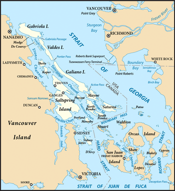
Separating Penelakut and Thetis Islands on the east side is Clam Bay, a large bay with good anchoring depths throughout. It offers one of the only large and protected anchorages on that side of land for several miles. It is connected to Telegraph Cove on the west side by ‘the cut’, a channel of shallow water that allows small boats to pass through. We chose to explore the cut by dingy and kayak.

Image from Fisheries and Oceans Canada
At Clam Bay I had my first experience of having to say ‘no’ to someone going from boat to boat to sell hand made crafts. Penelakut Island is owned by the Penelakut tribe. One evening a young man of this tribe paddled his canoe/kayak up to the boat and asked permission to tie up. He was selling lovely wooden animals, carved in his tribe’s tradition. He had some nice ravens, and a beautiful salmon. Alas, not only did we not have cash on hand, but we are not acquiring new decorative items for either the boat or the home. I had to say ‘no thank you’. We had a nice conversation whereby he told me he had three children, and he and his wife had just purchased their house, ahead of his older sister who had only recently married. He seemed pleased that he had managed to win this sibling competition. He had carved some of the objects, and his father had carved others. His oldest child, a girl of 8 years, had recently announced that she, too, wanted to learn carving. I hated to say no to him, but he took it gracefully and went on to the next boat. I hope he sold them all.

Clam Bay, Penelakut and Thetis Islands, east side. This is the true color of the sky. Brilliant rose pink for miles.
Patos Island
Patos Island is part of the San Juan Islands, so it’s on the American side. I’m glad, as it makes it that much easier to plan a trip back. If I could just get the boat up to Bellingham to stay in a marina up there, we could make the leap to the islands so much easier. It’s an idea we are toying with for our next boat.

Patos Island, looking up into the Strait of Georgia

And this one from the same place. Strange effect with the camera’s mirror makes this look like it’s an alien planet.
There are so many different land masses in this area that it’s unusual to get to see the sun actually set on the horizon. Maybe this is what it’s like out at sea where there is nothing to interfere with the view. Anchored off the north side of Patos Island we could see far up the Strait of Georgia until it looked like the land stopped. When we awoke in the morning, there was fog shrouding the land, but over the water it was clear, a strange looking phenomenon that happened several times during our trip. It was as though Moonrise were anchored at the edge of a great sea, the possibilities endless.
Looking back over this post I heave a big sigh and think it’s already time to go back. I wonder what it is like up there in the winter? Perhaps we will find out.